![]()
Home
Mission
Overview of Project
Project Staff
Sponsors
Achievements
Checking, Illustrations
Upcoming Activities
Id and Species Lists
Protea Information
Protea Gallery
Growing Proteas
Interim Dist. Maps
Publications
Afrikaanse Inligting
![]()
How Comprehensive were we?
![]() This
is a loaded question, since the answer depends on the scale at which we tackle the
problem. Here are some analyses for the Cape Flora.
This
is a loaded question, since the answer depends on the scale at which we tackle the
problem. Here are some analyses for the Cape Flora.
At the QDS scale (one 1:50 000 map) there are 240 grid squares (of 25 x 25 km) in the Cape Flora, of which 178 had Fynbos. We visited 199 of these, with a mean of 257 SRS per grid square. This suggests that the Fynbos maps are not accurate enough and need to be redrawn a little bit – yet another use for the Protea Atlas Project data!
At the EDS scale (of 12 x 12 km) there are 908 grid squares of which 551 have Fynbos. We visited 610 squares, with a mean of 84 SRS per grid square.
At the 1 minute scale (1.5 x 1.5 km) there are 43 744 grid squares, of which we have visited 23%. However, only 14 626 of these squares have Fynbos – of these we have visited 46%. Some of these no longer have Fynbos as they are urbanized, afforested, cultivated or heavily invaded. Of the 12 491 squares with more than half their Fynbos pristine, we have visited 48%. Note that these stats unfortunately do not include the area east of PE.
Of course, cur coverage varies with region. Summarizing these cells within degree blocks, the statistics are (note there are 3 600 minute cells in each degree square, but some of these are not Fynbos, or else are transformed):
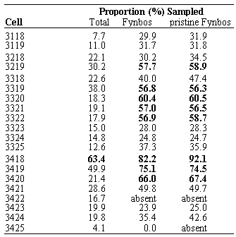
The minute by minute scale is especially interesting, as it is the scale at which we will be mapping species’ distributions using Bayesian modeling. Any large cluster of grid squares not visited will have to be interpolated and thus will need to be checked.
Areas particularly poorly atlassed are the Kouga (3323 & 3324), and Plettenberg Bay (3423) areas. However, the former probably has its Fynbos incorrectly mapped to include lots of thicket, so we may have more coverage than suspected. None of the Fynbos NW of Plettenberg Bay in 3324 has been atlassed.
Detailed maps of under-atlassed areas are available on the web and can be downloaded for viewing with ARC-EXPLORER for those atlassers with copies of PAPSRSDB.
Tony Rebelo
Back PAN 53