Home
Mission
Overview of Project
Project Staff
Sponsors
Achievements
Checking, Illustrations
Upcoming Activities
Id and Species Lists
Protea Information
Protea Gallery
Growing Proteas
Interim Dist. Maps
Publications
Afrikaanse Inligting
![]()
Filling in the Sight Record Sheets (1) decimal seconds
 I do not mind capturing data into the field notebook, but I
find the "locality box" a major bind. Part of the problem is
calculating the "decimal minutes": surely rounded-off minutes would be
perfectly adequate? Alternatively, could you not provide a simply look up table
so that I do not have to calculate coordinates every time. It should be a real
time-saver!
Ivor Jardine, Kenilworth
No, minutes are not adequate! Each minute is 1.85 X 1.55 km and our record localities have a maximum dimension of 500 m diameter. Thus in every square minute we would have over 9 record localities.
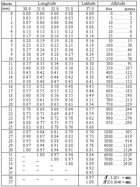
The table you have requested is presented opposite. It provides the decimal minutes required
for the atlas. It is only valid for the 1:50 000 scale map series, which most atlassers should be using. Should you have difficulties in obtaining these maps, we can photostat portions for you: please see the details in PAN 13: 4.
To interpolate data for intermediate values (eg 30.5 mm), simply take the middle value of the columns on each side. If you use maps which frequently require such values, then compile your own table as a handy quick reference.
You will be amazed at how much time this simple table saves!

Back PAN 14